
MoTuM
(Model Tumpahan Minyak)
Integrated Oil Spill Model into Three Dimensional Ocean Hydrodynamics Model using Non-Orthogonal Boundary Fitted Technique in Spherical Coordinate and Geographic Information System
|
|
|
Link:
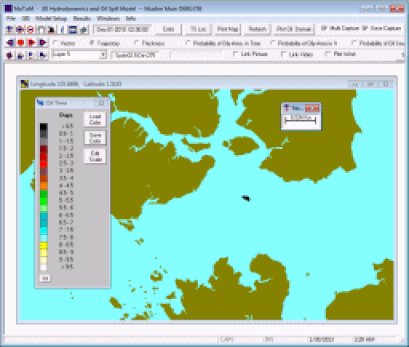
MoTuM Description
MoTuM or Model Tumpahan Minyak, is a customized Oil Spill Software (English or Bahasa Indonesia), copyright HAKI in 2005. Suitable for spill combating, contingency plan, and backtracking. The Oil Spill Model was coupled to 3D Non-Orthogonal Boundary Fitted Ocean Hydrodynamics Model. MoTuM had been widely used as part of oil spill contingency plan for drilling activities in Indonesia. With the integration of ocean hydrodynamics model makes MoTuM is easy to use. It comes with model setup (grid, open boundary, etc). The model had been successfully applied to track the source of spill for Balikpapan Spill Case in 2004. MoTuM had been proven as an accurate tool to simulate Montara Blowout Case. The results of simulation match 26 field observation (satelite images and flight observations).
|
MoTuM Users:
|
